
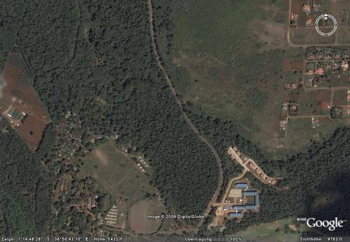
Kenya Tourists (KTs) will clearly identify this screenshot from GoogleEarth as Karura Forrest & CID HQ (blue roofs) next to Kiambu Road.
Kenya Residents (KRs, or Kenyan Roots as M puts it) will use this to remember what Karura Forrest looked like before it was castrated / sacrified for technological progress aka urbanization.
(technorati-should-be-keywords: how to we explain this to our children)
JKE, i am getting addicted to google earth or google ardhi as you call it he he, i have been trying out the 3D sketchup thing, i cant wait to do it for Nai, it appears that it requires a webcam set up? – not sure, jaribu?…
http://earth.google.com/3d.html
Keep the posts coming :)